VALUATION & ECONOMICS FOR DISCOVERY
- (a) the Landscape Economics Analysis technique described here.
- (b) The Proximity of Desire (POD) land valuation technique [link] is also useful to investigators.
LANDSCAPE ECONOMICS ANALYSIS (“LEA”) TECHNIQUE
a) Questions to frame discovery:
 This is to delve into the nature of the economics/market system that developed the site – to reimagine the site, culture, and technologies of the day:
-
- What technologies were available?
- What energy sources were available?
- What events influenced and might change the economics of production?
- What might the landscape have been like, and could there have been virgin territory?
- What was the economic value of the lands and how might this influence construction?
- What was the unit of mass production?
- What might the weather be over the four seasons?
b) Egyptology Analogy:
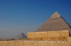
Consider the on-going challenge of determining the method of construction of the Pyramids at Giza.
Use the LEA questions’ framing technique to investigate the problem:
-
- What technologies were available?
- Slaves, hydraulics (sluices, dams, canals, pipes), donkey+gears+wheels, shadufs (water moving tech), barges and boats, slings, river fords, wagons, wind, timber
- What energy sources were available?
- Wind, water, sunlight, oil lamps, torches, labour
- What events influenced and might change the economics of production?
- Dynastic change, Success in wars = more slaves, climate changes = starvation
- What was the unit of mass production?
- Until modern times, this was the working population (slave, serf, fief-holder, parishioner) paid in various ways (slavery, food, tithes, faith, money). If a farm, how many hands were needed to sustain x-hectares of production, to feed x-population and a surplus?
- What might the weather be over the four seasons?
- Climate change, seasonal cycle of the Nile and tributaries.
- What technologies were available?
-
- What new information updates the query set?
- Recently scholars used lidar to discover a former channel of the Nile that passes near the main Pyramid sites at Giza:
- https:
//www. cbsnews. com/news/pyramid-mystery-long- lost-river-discovered-egypt/ - This generates investigation avenues, such as:
-
- What might the landscape have been like? (Lidar evidence of roads converging on ports and canals for materials transfer?)
- What was the economic value of the lands and how might this influence construction?
-
- https:
- Recently scholars used lidar to discover a former channel of the Nile that passes near the main Pyramid sites at Giza:
- What new information updates the query set?
c) A British Example:
-
- I noticed an oddity whilst watching the Whitestaunton Roman Villa episode of Time Team.
- This led to the question: Why did the Romans locate a villa on the ‘high value’ bottom land of the holding?
- https:
//davehuer. com/cartoproblematica/flungian /whitestaunton/re-settling-the -pocket/ - Whitestaunton Manor image shown above is by Roger Cornfoot under CC BY-SA 2.0

![https://creativecommons.org/licenses/by-sa/2.0/ The Manor House, Whitestaunton - Creative Commons Licence [Some Rights Reserved] © Copyright Roger Cornfoot and licensed for reuse under CC BY-SA 2.0](http://davehuer.com/cartoproblematica/wp-content/uploads/sites/4/2024/12/whitestaunton_5347197_066baa6b_original-300x230.jpg)