Discovering a lost First Nations trail
Horne Lake Provincial Park got created to protect a series of caves. When caving…one of the ways to avoid wasted bushwacking time is to digitally survey possible sites before going into the bush.
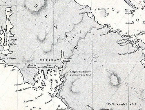
One of my projects has been tracing the lost Horne Lake trail from Port Alberni to Vancouver Island’s east coast:
- from colonial times (pre-1872)…
- to when British Columbia joined Confederation (1872); and…
- from the new surveyed and gazetted waggon road of that year (1872)…
- to the re-survey of a road allowance (1911), thence…
- to the modern, regionally negotiated public “Right-of-Way” (2010s)
By Fall 2016, a bit of success:
Independently finding two missing trails (Horne Lake survey, rough route of another trail), and the lost wagon road survey. Plus a portrait of Captain (later Admiral and Hydrographer) G.H.Richards, RN, held in private hands. Richards commanded the 1857-64 survey of the coast.
Route on 1856 Survey: [Direct Link] – Published at BC Caver [BC Caver newsletter: S-2016, p.34]
Federal and BC Crown agencies, local government, all three local First Nations (Qualicum, K’omoks, Tseshaht), and post-Conquest landowners have searched for the maps and associated reports since 1905. It took me 4 years and digitization helped. By Nov 2016:
- Physical visits: 3 archives
- Digital visits: 15 archives in 7 countries
- Too many records to count
The modern route goes past a provincial park which has caves. Today’s Horne Lake Trail is not the original trail but was thought to be. The original trail got built and used for centuries by First Nations’ traders and (HBC fur traders, colonial era Crown employees, and settlers by foot and pack animal) but never by wagons or industrial era transport, and lost to memory sometime during the 1880s. The discovery is that the lake is part of the original trail; a water portage through what was then thickly wooded old growth forest clothing the mountain pass.
Net Effect: Influences at least three overlapping First Nations treaty claims, public policy, real estate rights, archaeology, and public spend. Most readers know that I solve intractable logic problems (note “**” below). I’ve worked out an investigative path to another cache of colonial era documents. Like as not will have time when in some far distant future, I retire. It is probably on the order of $100,000 worth of time, so won’t be happening for a while.
** Example (1): Preventing failure of the Busy Place Creek “stormwater pond” project at Koksilah Industrial Area, City of Duncan, Duncan, BC, for The Partnership for Water Sustainability in BC. Initiative: Noticing and alerting Prime Contractor to the presence of an underground river below the job site, in the data flows in my imagination. Cost savings estimate: $100,000-200,000 + future harm to reputation of stakeholders + future liabilities and costs of failure during a flood event: https://davehuer.com/wp-content/uploads/2019/06/David-Huer_buried-river-flood-source_2018b.pdf ; Example (2): https://www.linkedin.com/in/davehuer/