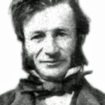
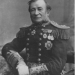
 Commanding the in-shore survey of BC Waters
Later: Admiral & Hydrographer of the Navy
His work continues to inform Canadian charts.
Overarching Timeline of the Period
- (1846) Oregon Treaty – HBC moves Pacific headquarters to Vancouver Island.
- (1849) 13 Jan 1849 – Colonial Office gives HBC a 10-year lease on the condition that it establish a colony. The Colonial Office designated the first Governor (Blanshard), but the arrangement failed due to objectional behaviour by HBC staff who were also Colony employees. London ultimately designated HBC Chief Factor James Douglas to also wear the hat of Governor, but this ultimately failed from conflicts of interest.
- (1859) HBC contract ends. The Colony of the Island of Vancouver and its Dependencies established (CVID).
- (1866) CIVD & Colony of British Columbia (CBC) combined.
- (1867) 3 April: Administration was re-conveyed to the Colonial Office.
- (1871) BC joins Canada, assuming the status of a Province.
Admiralty interest during early Colonial/Provincial Era
1) Protecting Pacific Interests: (a) HBC’s Fort Victoria, 1843-1864 [briefly Fort Albert, renamed on June 10, 1843, by resolution of HBC’s Council of the Northern Department]. (b) Later, HMC Dockyard & Navy Base: Protecting Pacific trade + easy access to Sandwich Islands (Hawai’i) and Chile. (c) Later still: Protecting the Imperial telegraph station at Bamfield: this is the village nearest to the Barclay Sound terminus of the trans-Pacific cable.
2) Nanaimo, BC: The town has commercially valuable fuel coal deposits. The Nanaimo coalfield was the only secure source north of Chile during that tenuous time after the Oregon dispute. First Nations people told colonial officials (who were also HBC officials) about the deposits. HBC got the mining and vessel coaling concession rights (including contract to supply HM Ships), and then certain colonial officials managed to get the rights for themselves.
3) Alberni Canal (“Channel”): The fjord is accessible by deep draft vessels. In this era, heavily covered in old-growth forest. Merchant sailor Captain Edward Stamp built a sawmill and sold spars to the Navy and to customers around the Pacific. Stamp obtained a grant of 15,000 acres from the newly founded colonial legislature (1861).
Note: Stamp’s Mill was privately backed by Anderson, Anderson, & Co. (AA&C). This was a Thameside firm which started as a victualing contractor, branched out into building and operating ships, and during this period acquired timber properties around the world to supply customers. The Alberni facility shipped product to AA&C’s English shipyards and to customers around the Pacific Rim.
AA&C became P&O Lines – now a unit of Dubai World. P&O’s archives are incomplete – their archivist tells me many records were destroyed during the Blitz.
** thus, when UK Archives are searching for pre-WWII mss, success might be found by developing a database of sources in former possessions. For example, the P&O Archivist did not know that AA&C had owned properties in BC. The regional archivist in Alberni has details on AA&C properties in that District. **
5) Horne’s Trail: The Navy’s interest was to prevent an attack on Nanaimo’s important coaling station (invasion via the Alberni Canal) – and a quick communication link between the Interior of the Island and Fort Victoria. Military and economic interests later produced an intermediate plan to run a canal (with locks, like the Rideau Canal near Ottawa) from Alberni Canal to Nanaimo – but fell through when telegraph technology entered the military use.
Reasons for Colonial Interest in an enlarged RN Presence
1) Protecting Tax Revenues: Gold fields owned by the Crown (English statutes) being illegally mined.
2) Massive influx of Americans: from Oregon and California to the gold fields, ignoring British law and the treaty between the United States and Great Britain.
3) Consequent danger of a sort of civil “coup de main”: This was the great fear of colonial officials and settlers. The influx of fortune-seekers along a largely indefensible border led to despatch of the first security detachment commanded by Col. Moody, RE: https://en.wikipedia.org/wiki/Richard_Clement_Moody
4) Unresolved border through the Gulf Islands: Richards’ charting duties including fixing the border alongside US commissioners.
Horne Lake Trail
The Qualicum People created and used the trail across the mountain pass from the inland sea to the Alberni Inlet. The trail traversed the large lake known as Enoksasent.
The Hudson Bay Company pursued the fur trade across what is now Western Canada and this included Vancouver Island. In 1852, HBC established a trading fort with a two-story blockhouse (“The Bastion” – still standing) for refuge at Nanaimo. In 1856, the Company sent storekeeper Adam Horne from Nanaimo to investigate reports of a trail from Quallchum (Qualicum) to Alberni that might provide an overland route from the east coast to the Alberni Canal fjord. With aboriginal guides, Horne was able to travel, sketch, and return using the trail. In Oct 1856, Colonial Governor Douglas sent surveyor Joseph Pemberton to survey the trail route into the interior. He reported back in Dec. 1856. Douglas the Factor reported to HBC HQ in Jan.1857.
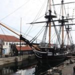
In Sep 1857, Pemberton re-crossed the mid-coast a second time; this time accompanied by Lt. T.S.Gooch of H.M.S. Satellite, and a party of seven. They left Cowichan Harbour on Sept 4th and reached Nitinat on the West Coast on Sept 19th. Each man carried a 60-lb. pack, in addition to arms and ammunition for hunting and defence. This is rough, mountainous country, at this time thick with old growth forest and undergrowth.
Governor Douglas, and Surveyor-General Pemberton were simultaneously District Managers for the Hudson’s Bay Company; and participated by subterfuge to extend the aims of the company first and Government second. This included keeping knowledge of the trail away from Captain Richards, and not informing the Colonial Office and through them Parliament (which during 1859, held an inquiry into the continuance of the Company’s monopoly, granted 1670).
The Company’s attempt to keep knowledge of the trail out of Government hands failed. Horne directly mentioned news of the trail to Richards, and Pemberton gave Richards a tracing of the survey in June-July 1858 when the two surveyors met at Barclay Sound.


Until Nov 2016’s discovery, the belief on Vancouver Island was that the trail went around the lake. The 1856 HBC map shows the trail ending at each end of the lake.
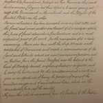
This, coupled with repeatedly expressed newcomer astonishment whence discovering a canoe at either end of the lake, suggests that the Lake is the trail – a “reverse portage” enabling trail travelers to swiftly travel through a long section of the pass.Richards used the tracing as a guide for Navy activities [see photocopied survey reports at UBC Archives].
This is the trail traversed by Richards and staff, who used the tracing as a guide for Navy activities [see photocopied survey reports at UBC Archives].
- 1859 – Lt. Mayne travels trail as one leg of a circular route from the head of Alberni Canal to Nanaimo and back.
- 1859 (July) – Richards walked the trail to check the notes, accompanied by staff including Master Bedwell, RN.
- 1860 (March) – Master Bedwell sketched the valley at the head of Alberni Canal from the viewpoint on the trail where it crests View Mountain, looking west. View Mountain is immediately east of Alberni. [Master Bedwell is Edward Parker Bedwell, second master aboard HM surveying vessel Plumper, 1857-60. Master 1860, and appointed to HMS Hecate, which vessel relieved the Plumper of her surveying duties in December 1860. Staff commander, retired, 1870].