 Col. Engineer Römer’s ca. 1698 Memorial & Mappe
I’ve been searching out liming technologies (kilns of various designs) and from this have been on the trail of Col. Engineer Römer’s Memorial (Report with accompanying Map) of an inspection trip to upper New York State. The Report went to Lord Bellomont, Governor of New York. The Mahone Bay hypothesis is that New Englanders smuggled lime to Boston (ending circa 1697 when Massachusetts residents found deposits at Newbury, MA), and Newfoundland’s large Baie Placentia French settlements until the Treaty of Paris (1763).* I’ve been looking for it as it was prepared at the tail end of the proposed lime smuggling trading window.
Quicklime
Quicklime (“lime”) is from limestone. Its cheap substitutes were oyster-lime and bird-shell lime. Quicklime was a strategic material (fortress mortar), disinfectant (limeslake), fire protection (whitewash), and fertilizer (for acidic soils). All of these important applications and the interests of William III, George III, and William IV led me to investigate original British holdings.
A thank you to Archivists
I must say, every archivist I’ve reached out to has been extraordinarily helpful. Their names are not listed here for privacy’s sake, but you know who you are. Thanks much to all.
 5 Indian Nations
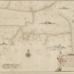
We have one surviving copy of the Mappe at the British Library.
But the Report appears to have been lost.
Map Title: A Mappe of Colonel Römers Voyage to ye: 5 Indian nations going from New Yorck to Albany thence west to ye 3 Macquas Castle and from ye: last Castle called Daganhoge W:S:W towards Onyades a Second nation, and thence to ye Onondages the third nation, & there I was Stoped & could not proced any forther for some important reassons & obliged to go from Onondages to ye Lake of Cananda down Cananda River till we met Onnondages River & Osweges Riv: from whence we were to returne towards Onnondages having no provision & thence to Ononyedes & from thence to ye carring place wood kill & Bever kill & so to Oneyades agin & thence to Albany as it is set forth with read pricked lines
Year: circa 1698?-1700
From: Col. Engineer Römer https://en.wikipedia.org/wiki/Wolfgang_William_Romer
To: Lord Bellomont https://en.wikipedia.org/wiki/Richard_Coote,_1st_Earl_of_Bellomont
Source images:
Norman B. Leventhal Map Center, Boston Public Library, MA: https://collections.leventhalmap.org/search/commonwealth:hx11z585s
NY State Public Library, New York, NY: http://nysl.cloudapp.net/awweb/guest.jsp?smd=1&cl=all_lib&lb_document_id=66822
Original: British Library: Cartographic Items Maps K.Top.121.10. http://explore.bl.uk/BLVU1:LSCOP-ALL:BLL01004987682
My particular interest is that the Memorial reportedly contains notes about colonial-era lime manufacture:
- “various maps and designs”;
- “Demonstrates the proper method of preparing lime”;
- “Sketch of method of preparing lime.”;
- “A drawing of the engine for making lime.”;
Research Trail Notes:
1) Observing notations about lime at British History On-line:
http://www.british-history.ac.uk/cal-state-papers/colonial/america-west-indies/vol18/pp354-380. June 22. Boston. “I send Col. Romer’s Memorial, which I have turned into English.” Refers to various maps and designs enclosed….580. xii. Col. Romer to Lord Bellomont. New York, Oct. 12, 1698. Demonstrates the proper method of preparing lime on the frontiers of New York. Encloses designs and estimates.
http://www.british-history.ac.uk/cal-state-papers/colonial/america-west-indies/vol16/pp472-478. Oct. 12. New York. 886. Colonel Romer’s report to Lord Bellomont on the fortifications of New York. “I send the plans of the several works which I have designed [missing]. If any works be begun during my absence, the lime burned out of stone at Albany is not sufficiently good for the work, as it does not dissolve itself—I suggest the following method for dissolving it. Here follow elaborate details as to the method,… ”
2) Went searching for the Memorial at UK National Archives. No luck.
3) Went searching for map copies. Finding the B&W image at NY State Library, and colour copy at Boston PL. Both note provenance as British Museum.
4) Reached out to British Museum (BM). Their Volunteer Archivist cannot find any trace of BM having held Romer’s Memorial but suspects it may have been held here but just not registered. BM transferred this map to British Library, and BM Central Archivist suggested contacting the Library directly, suspecting that the report, if present, would have been transferred at the same time as the map. The map was part of King George III’s collection donated by George IV.
5) Reached out to British Library (BL). BL Reference Services helpfully sought the advice of the former Head of the Map Collections, who thinks that:
“The report would have probably have gone to the Board of Ordnance rather than to the Council of Trade and Plantations – but whatever the route it would ultimately have ended up in the TNA [The National Archives] if it had survived. It is possible, however, that there was a quite separate report addressed to the Queen or her consort, George of Denmark [“William III”? – D.Huer]. In that case it could either be in the Royal Archives (though I doubt it – I suspect that their holdings for that period are poor) or that it could have found its way into the King’s MSS as happened with several items that seem originally to have formed part of George III’s geographical collections (for instance the De Brahm report, with maps, on the Southern District of the American colonies presented by him to George III in 1773 and now, I think, King’s MSS 220, 221)).”
a) BL References checked and found no references.
b) BL References checked Römer’s private archives listed by the TNA and found references only to his will and to correspondence of 1712 relating to fortifications in the North MSS in the Bodleian Library.
6) Reached out to The Royal Collection Trust. The Trust curates the Royal Collection, and manages public areas of official residences of Her Majesty The Queen. My query was passed to the Keeper of The Queen’s Archives, and thence to the Senior Curator of Prints and Drawings. The Royal Archives often might have the only copy of a work, and if this is a possibility, they are sometimes able to check. Here, I could provide documentation of the trail investigated thus far – thus suggesting, indeed, that HM Collections may have the only copy.
But alas! No luck.
a) The Memorial and/or Mappe documents are not in the Royal Collection; and The RoyalArchives’ reports that they “have checked through a number of the indexes but have been unable to find any reference to the memorial report; however, as The RoyalArchives records predominately start with the reign of George III (1760-1820),” this, I am advised, “is unsurprising.”
b) The British-History reference notes that the report – with maps (plural) – sent to London was translated into English before being sent to the King; so I also asked whether the Hanoverian-era Kings have retained the German version. But again, no luck. There are no copies in German either.
c) The Senior Curator suggested the following link of interest: www.royalcollection.org.uk/collection/georgian-papers-programme#/yalcollection.org.uk , noting that “Unfortunately the index to the Georgian Papers is not currently structured in a way that allows for subject based searching, and therefore they are unable to be of much assistance with your research on quicklime.”
FYI: Records of the earlier monarchs are stored at The National Archives: www.nationalarchives.gov.uk/
_(2).jpg) 7) But all is not lost.
7) But all is not lost.
There are other avenues, and I continue to search.
* Treaty of Paris (1763): The Treaty included the agreement that France retain the islands of St. Pierre et Miquelon off the coast of Newfoundland, to have access to the Atlantic fisheries. Which, by happenstance, is why France now controls a swatch of seabed oil & gas exploration rights running SE from the islands to the edge of Canada’s 200-nau.mile Exclusive Economic Zone.
Mappe Image: Leventhal Map Center – Creative Commons Attribution Non-Commercial Share Alike License (CC BY-NC-SA).
Ship Image: Clipped from my favourite map of all time, Petrus Plancius’ 1592 tour de force: https://sv.wikipedia.org/wiki/Petrus_Plancius#/media/File:1592_4_Nova_Doetecum_mr.jpg (Public Domain).
Compass Image: By Virginia State Parks staff (Compass Uploaded by AlbertHerring) [CC BY 2.0 (http://creativecommons.org/licenses/by/2.0)], via Wikimedia Commons: https://commons.wikimedia.org/wiki/File%3ACompass_(5851212744)_(2).jpg