LiDAR Reveals an Ancient Roman Highway
 I’ve been reviewing LiDAR plots at work. And sideways to that, when investigating the method for Cartoproblematica, came across a fascinating new article from the journal PLoS ONE, reported in RealClearScience.
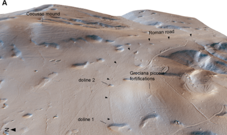
Archaeologists have discovered an ancient Roman highway, scant centimeters deep, “stand(ing) out clearly in exquisite images created with LiDAR mapping technology.
LiDAR is carried out with a laser-firing device, often mounted onto a helicopter. For the current study, roughly four to five laser shots were fired every square meter over the survey region to measure detailed distances. When combined with geographic information system (GIS) mapping technology, the distance data allowed for the creation of a 3D map which can reveal otherwise hidden structures and formations.
RealClearScience reports: “the authors estimate that the road may have been in use between the 2nd century BC and the 2nd century AD, as long as 300 to 400 years! Sometime after it fell into disuse, two sinkholes opened along its path.”
Making this a case of karst coming after the horse. 🙂
References:
RealClearScience report: https://www.realclearscience.com/quick_and_clear_science/2018/03/26/lidar_reveals_an_ancient_roman_highway.html
Image & original article source: Bernardini F, Vinci G, Forte E, Furlani S, Pipan M, Biolchi S, et al. (2018) Discovery of ancient Roman “highway” reveals geomorphic changes in karst environments during historic times. PLoS ONE 13(3): e0194939. https://doi.org/ 10.1371/journal.pone.0194939
LiDAR: https://www.scientificamerican.com/article/meet-lidar-the-amazing-laser-technology-that-s-helping-archaeologists-discover-lost-cities/