Skip to content (Press Enter)
CartoProblematica

CartoProblematica

discovering unknown treasure in the karst & cave mapping of the world & the reproducible evidence thereto

  • Peregrinations*
    • Hypothesis Development Techniques
    • Funding Archae/History Discovery
    • Citizen Discovery
    • Call, Don’t Dig
    • Helpers & Contributors
    • 1848 & All That
    • About David Huer
  • Atlantean
    • Did the American Revolutionary War start in 17th C Acadia?
      • Mahone Bay Treasures
        • Research Notes
          • Mahone Bay – Docs & Data
          • Mahone Bay – Charts & Surveys
            • 1604 Pilot’s Rutter
            • Charts & Surveys 16th C to 1710
            • Charts & Surveys 1710 to 1800
            • Charts & Surveys 1800 to 1900
            • Additional Atlantic Charts
            • Charts & Surveys – Science
          • Theory Notes
          • Mahone Evidence Testing
      • Oak Island Science
    • 1698 Hudson River Expedition
    • 1744 Duc d’Anville expedition
  • Pacifican
    • Closed Projects
      • Alberni to the Coast
        • Horne Lake’s Treasures
          • Hypotheses – Horne Lake
          • Tracing the Pre-Contact Trail
            • Captain G.H.Richards, RN
            • Finding a Lost First Nations Trail
            • Horne Lake – Docs & Data – pre-1856 Trail
            • Horne Evidence Testing
            • Horne Mapping Images
            • Horne Lake – Maps & Images
            • Treaty implications
          • 1871/72 Waggon Trail survey
          • National Park concepts
          • New Explorations
  • Passagean
    • Champlain 1613
  • Flungian
    • St. Osyth’s 15th Century Mill Dams
    • Whitestaunton’s Roman Villa
      • Re-Settling the Pocket
        • Site Assumptions
        • Village Site
        • Round Copse
        • Regional Context
        • Images & Sources
CartoProblematica

CartoProblematica

discovering unknown treasure in the karst & cave mapping of the world & the reproducible evidence thereto

  • Peregrinations*
    • Hypothesis Development Techniques
    • Funding Archae/History Discovery
    • Citizen Discovery
    • Call, Don’t Dig
    • Helpers & Contributors
    • 1848 & All That
    • About David Huer
  • Atlantean
    • Did the American Revolutionary War start in 17th C Acadia?
      • Mahone Bay Treasures
        • Research Notes
          • Mahone Bay – Docs & Data
          • Mahone Bay – Charts & Surveys
            • 1604 Pilot’s Rutter
            • Charts & Surveys 16th C to 1710
            • Charts & Surveys 1710 to 1800
            • Charts & Surveys 1800 to 1900
            • Additional Atlantic Charts
            • Charts & Surveys – Science
          • Theory Notes
          • Mahone Evidence Testing
      • Oak Island Science
    • 1698 Hudson River Expedition
    • 1744 Duc d’Anville expedition
  • Pacifican
    • Closed Projects
      • Alberni to the Coast
        • Horne Lake’s Treasures
          • Hypotheses – Horne Lake
          • Tracing the Pre-Contact Trail
            • Captain G.H.Richards, RN
            • Finding a Lost First Nations Trail
            • Horne Lake – Docs & Data – pre-1856 Trail
            • Horne Evidence Testing
            • Horne Mapping Images
            • Horne Lake – Maps & Images
            • Treaty implications
          • 1871/72 Waggon Trail survey
          • National Park concepts
          • New Explorations
  • Passagean
    • Champlain 1613
  • Flungian
    • St. Osyth’s 15th Century Mill Dams
    • Whitestaunton’s Roman Villa
      • Re-Settling the Pocket
        • Site Assumptions
        • Village Site
        • Round Copse
        • Regional Context
        • Images & Sources
Home>British Colonial History

British Colonial History

February 19, 2019

1854 Victoria, BC Survey

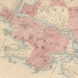
Whilst researching land issues in the provincial Capital Regional District (Victoria, BC) came across an 1854 survey of properties. This …

Read More
November 29, 2018

York (Toronto)’s War of 1812 Garrison Flag

The British Royal Standard flown by the office of the Lieutenant-Governor of Upper Canada from 1801-1813, until captured by American …

Read More
October 20, 2017

Col. Engineer Römer’s 1698 Memorial – Found a clue!

I found a clue and following it up, back to England we go! Image: Magnifying glass on antique table. https://commons.wikimedia.org/wiki/File:Magnifying_glass_on_antique_table.jpg …

Read More
StumbleUponwordpress

Recent Posts

  • on hiatus
  • 1854 Victoria, BC Survey
  • Parliament’s Shoulder Patch
  • A “Stirling” map of Newfoundland?
  • Whitestaunton Hypothesis

Recent Comments

  • innovadmin on (1684) Manuscript journal of the ship “Marianne”
  • Marc-André Comeau on (1684) Manuscript journal of the ship “Marianne”
  • Marlene Smulders on Mahone Bay – Charts & Surveys

Archives

  • June 2019
  • February 2019
  • January 2019
  • December 2018
  • November 2018
  • July 2018
  • March 2018
  • January 2018
  • December 2017
  • October 2017
  • September 2017
  • June 2017
  • May 2017

© David Huer 2017-present

If non-commercial, cite authorship. If commercial, corporate and/or government, please contact me to request permission. Our icon - modified from Seutter's 1715-1758 map using www.gimp.org, viz. Partiale Orientale de la Novelle France or du Canada avec L'Isle de Terre-Neuve et de Novelle Ecosse Acadie... Seutter Georg. De S.M. Imper d'Augsbourg. Copy at Acadia Univ. http://openarchive.acadiau.ca/cdm/singleitem/collection/Morse/id/59/rec/1
© 2025 CartoProblematica. Metro Magazine | Developed By Rara Theme. Powered by WordPress.